GO AD-FREE. Get 2 Months Digital Subscription for ONLY £1! Use code 2FOR1
GET STARTEDMore on KentOnline
GO AD-FREE. Get 2 Months Digital Subscription for ONLY £1! Use code 2FOR1
GET STARTEDMore on KentOnline
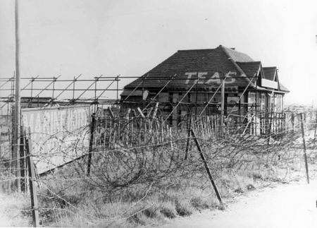
This cafe at Tankerton was cut off by barbed wire and coastal defences. Picture dated April, 1945
If you know where to look, the traces of war are still to be found along the Kent coastline.
Concrete blocks, known as dragons’ teeth or coffins because of their shapes, were sown in the ground in their hundreds to stop tanks. Some remain, like rotting teeth.
Crumbling pillboxes, originally camouflaged as farm buildings, cottages or even haystacks, are hidden in undergrowth.
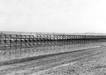
Stunted remains of scaffold poles, once part of our first line of coastal defence, stick from the mud at low tide.

All still there 70 years after the Second World War began - for the north Kent coast was once part of Britain’s frontline.
As the nation braced itself for the likelihood of a Nazi invasion the coastline was defended with what was known as the “coastal crust” - a scaffold pole fence strung with barbed wire and backed-up with minefields, anti-tank traps and pillboxes.
Now those dark days are being recalled in a new exhibition, the Forgotten Frontline, which opens at the Whitstable Museum and Gallery on Saturday, September 12 and runs until November 16.
Local historian, archaeologist and senior Kent police officer Mark Harrison has been using his detection skills to gather material for the exhibition for the last two or three years.
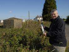
“Many people have had remarkable stories to tell about wartime Whitstable,” he said. “But others have no idea of what life was like living under the shadow of enemy attack from sea or air at any time.
“The purpose of the exhibition is to show how the area from Seasalter to Swalecliffe prepared for war and faced up to the very real prospect of a German invasion.”
The centrepiece of the exhibition is a wall display of aerial photographs showing many of the wartime defensive structures in the Whitstable area.
The photographs were taken by the RAF as part of a national survey in 1946 to assess the damage inflicted by the war.
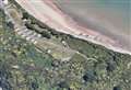
Faversham Road in Seasalter, opposite Waldens Store
Photographs, including some rarely shown ones, from the KM Group’s wartime are also among the exhibits.
Organisers are local history group Timescapes, Mapping Kent, historian Dr Sandra Dunster and Canterbury City Council, with support from numerous organisations including Kent County Council, English Heritage, Heritage Open Days, Kent Coastal Network, Whitstable Improvement Trust and the KM Group.
Contact the museum on 01227 276998 or visit www.timescapes.spaces.live.com