GO AD-FREE. Get 2 Months Digital Subscription for ONLY £1! Use code 2FOR1
GET STARTEDMore on KentOnline
GO AD-FREE. Get 2 Months Digital Subscription for ONLY £1! Use code 2FOR1
GET STARTEDMore on KentOnline
This weekend feels more like winter than spring as snow falls across the county.
The Met Office has issued an amber weather "be prepared" warning for the north, west and parts of the east of Kent between 4pm today and 9am tomorrow.
A yellow "be aware" warning covering the whole county was already in place for Saturday and Sunday. An ice warning has also been put out until 10am on Monday.
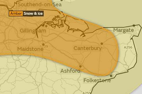
The Met Office says a band of rain will turn more widely to snow, followed by scattered snow showers through the remainder of the day.
These showers may become more prolonged, particularly during the evening.
Any melting of lying snow will lead to an ice risk on untreated surfaces tomorrow morning and night.
It is not clear where snow will settle as showers are expected to organise into bands, but while some areas will see small amounts of the white stuff, others are likely to see five to 10cm.
Strongly easterly winds will also cause snow drifts, leading to "significant wind chill".
Public transport could also prove problematic but Southeastern says it plans to run its normal weekend timetable.
Listen to kmfm for the latest travel and weather updates