GO AD-FREE. Get 2 Months Digital Subscription for ONLY £1! Use code 2FOR1
GET STARTEDMore on KentOnline
GO AD-FREE. Get 2 Months Digital Subscription for ONLY £1! Use code 2FOR1
GET STARTEDMore on KentOnline
Map showing Kent's nuclear danger zones, according to a new website
by Tim Collins
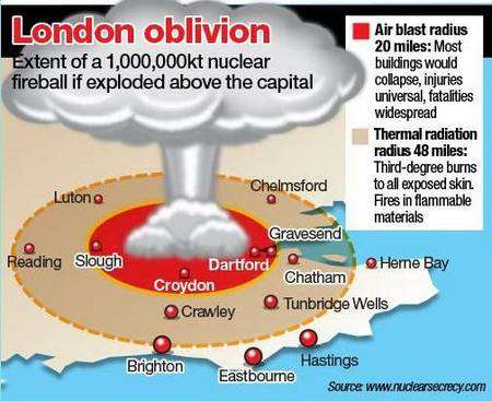
The blast from a nuclear bomb falling on London would wipe out a large part of north Kent, according to a new website.
Nukemap calculates the effects of various radioactive devices and what would happen within the radius of the explosion.
It shows the population of Dartford and Gravesend would likely perish with most buildings collapsing - and people in huge swathes of west Kent left suffering from third-degree burns from thermal radiation.
The grim forecast is predicted in the event of a detonation in the capital of the type tested recently by North Korea.

North Korean leader Kim Jong-un has been ratcheting up tensions
Tensions have risen over North Korea's ongoing nuclear threats to the West following claims of a successful underground test in February.
Alex Wellerstein, an American historian of science who specialises in the history of nuclear weapons and nuclear secrecy, has created Nukemap.
Using Google Maps, the website contains a nuclear effects calculator that predicts the impact from a range of blasts, allowing the user to select the size of the bomb and the location of its detonation.
Among the gruesome effects detailed are the radius of any fireball, air-blast, thermal and nuclear radiation, but not the fallout cloud of radioactive dust that could follow.
But it would take an explosion of 100 megatons or larger, equivalent to the largest nuclear bomb ever designed - the Russian Tsar Bomba - to be launched at London to trigger the widespread effects in Kent.