GO AD-FREE. Get 2 Months Digital Subscription for ONLY £1! Use code 2FOR1
GET STARTEDMore on KentOnline
GO AD-FREE. Get 2 Months Digital Subscription for ONLY £1! Use code 2FOR1
GET STARTEDMore on KentOnline
Nazi bomber crews returned to their home bases in the Second World War, congratulating themselves on having destroyed a valuable target.
But the chances are they had been fooled into dropping their bombs harmlessly on marshland.
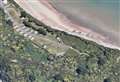
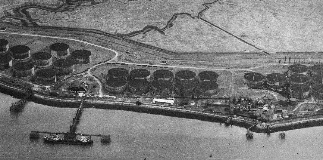
The Second World War bombing decoy site at Allhallows was built by Winston Churchill’s Petroleum Board in 1941, as part of a national programme of homeland defences to draw enemy attack away from real fuel storage facilities.
During 1941-42, there were nearly 840 decoy sites in operation, ranging from dummy airfields and oil installations to decoy towns on fire.
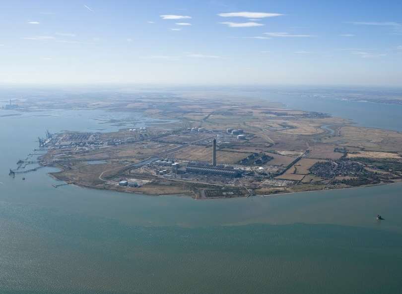
The Allhallows decoy was situated around three kilometres to the north-west of a large complex of around 100 real oil storage tanks on the Isle of Grain.
More remarkable is the entire decoy complex can still be seen in the landscape today, either as vegetation marks, structural remains or as archaeological features.
They include five oil pools in the shape of rings and crescents and channels which held burning fuel.
When set alight and viewed from above, the shapes created gave the impression of burning oil drums and storage tanks.
The decoy was ignited electrically from a remote control building, the remains of which are also still visible.
The fake oil storage depot and a rare 17th century decoy duck pond are among the forgotten slices of Medway’s history unearthed on the peninsula by conservationists.
As well as these two finds, two boundary stones marking the outermost limit of the City of London’s control of rights on the River Thames, now have listed status.
Ducks flying over the Hoo Peninsula were fooled by the decoy in much the same way as Lufwaffe pilots were.
Their undoing was a pond, which wasn’t really a pond.
The duck decoy pond is on High Halstow marshes and two London boundary stones at Yantlet Creek and Upnor.
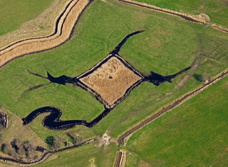
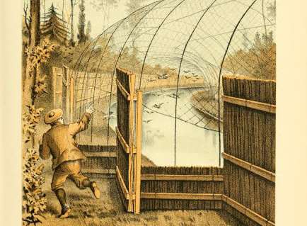
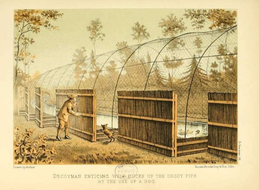
The pond is the well-preserved and partly waterfilled remains of a 17th-century structure. It is the only surviving example of four such ponds known to have existed in Kent.
Ponds like these were introduced into England from the Netherlands and were often built by the gentry, gaining more popularity during the 18th and 19th centuries.
The decoy ponds consisted of a central pond with a number of curving and gradually narrowing channels leading away.
These channels, known as pipes, were enclosed with netting, and wildfowl which had settled on the pond and made their way to the end of the pipes had nowhere else to go…except the dinner table.
Their finds, on stretches of marshland which have remained relatively undisturbed, have been revealed by Historic England, formerly English Heritage.
A new book published by the organisation also reveals other important rare finds unearthed in the area.
The discoveries now have protected status.
Historic England experts have been uncovering and protecting the extraordinary historic sites on the peninsula, which have until now been little known beyond Medway, despite being only 30 miles or so from the capital.
Experts have researched and mapped the landscape, archaeology and development of the area.
They say many of the events and activities that have taken place there over the centuries have been part of much bigger stories with national, and sometimes international significance.
On the advice of Historic England, the Department for Culture, Media and Sport has granted protection to the four sites.
Sarah Newsome, senior investigator at Historic England, said: “The duck decoy pond and oil decoy we investigated are fascinating examples, centuries apart, of the rich history of the Hoo Peninsula.
“These historic sites represent so many aspects of human activity; from putting food on the table to the preservation of life itself during the Second World War.
“Through this project, we have revealed that the Hoo has a complex history that goes beyond the familiar Dickensian idea of a low-lying land of misty marshes.”
The new book, The Hoo Peninsula Landscape, by Sarah Newsome, Edward Carpenter and Peter Kendall is out this week and is priced at £14.99.