GO AD-FREE. Get 2 Months Digital Subscription for ONLY £1! Use code 2FOR1
GET STARTEDMore on KentOnline
GO AD-FREE. Get 2 Months Digital Subscription for ONLY £1! Use code 2FOR1
GET STARTEDMore on KentOnline
New colourful maps are showing cyclists and visitors how to get around a seaside town on foot and by pedalling.
Two are already installed in Deal town centre and a third is planned in the coming weeks.
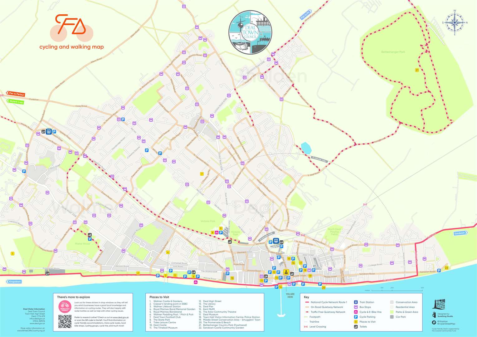
It's all part of Deal Town Council’s Cycle Friendly Deal project, withfunding from the Government’s Coastal Community Fund.
The scheme aims to attract cycle tourism while reducing emissions in Deal and on visitors' journeys here.
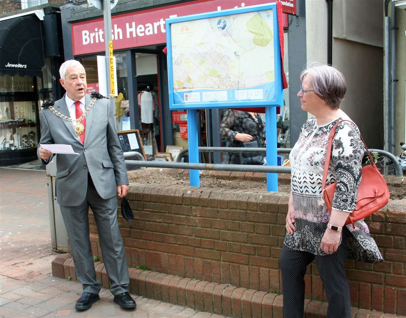
The new displays are in the High Street at the junctions of Park Street and South Street. A third will be installed outside the Town Hall later this summer.
The maps cover Deal, Walmer and Sholden, where Betteshanger Park already attracts visitors. The size of the map allows a lot of detail to be added including places to visit, conservation areas, bus stops, public toilets, cycle parking, green spaces, footpaths and cycle paths.
A handy feature illustrates what is within a five minute cycling zone of the location of the map.

For example, from Park Street, a rider could reach Harold Road to the North, Southwall Road inland and York and Campbell Road in Walmer to the south.
The new map introduces the Cycle Quietway Network.
A statement from DTC said: "This has been developed with local riders and it uses traffic free cycle paths and low traffic roads to connect quickly and easily with the places people want to go.
"Everyone is within a couple of minutes of the Quietway Network."
The Cycle Friendly Deal team asked a grandmother and her five-year-old granddaughter to test the Cycle Quietway Network and with their help the Quietway routes were further improved.
"Cycling visitors spend money in the town without polluting our environment..."
Unveiling the map on Saturday, June 12, mayor Cllr Chris Turner, said, “I’m delighted to unveil this new map of Deal Town and the surrounding area, especially as it emphasises cycling and walking routes.
"There’s so much detail here that it is great for locals and visitors.
"Whilst the Cycle Friendly Deal project has formally ended, its work will continue encouraging more sustainable tourism to Deal and at the heart of a drive towards more active travel for all of us.”
Deputy mayor and lead councillor on the project, Cllr Sue Beer said, “It is good to know that Deal is even better placed now to welcome cyclists to the town.
"Cycling visitors spend money in the town without polluting our environment.
"If more local people choose to leave their cars at home and cycle or walk, that will be even better.”
A free pocket-sized version of the map is available from the Visitor Information Centre, Saturday Market, shops, supermarkets and other locations across the area.
For more information visit the council's Cycle Friendly Deal page at deal.gov.uk