Unlimited Digital Access / Get £25 off your Annual Digital Subscription! Use code 25OFF
GET STARTEDMore on KentOnline
Unlimited Digital Access / Get £25 off your Annual Digital Subscription! Use code 25OFF
GET STARTEDMore on KentOnline
Gusts of up to 75mph are set to batter the Kent coast as another yellow weather warning for wind has been issued.
The Met Office alert stretches across the south of England and is in place from 11am on Saturday to 3am on Sunday.
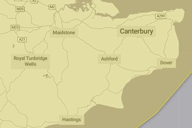
Forecasters are warning of likely travel disruption and large waves crashing over seafronts.
Strong gales between 45 to 50 mph and heavy rain are set to hit all of the county, while the strongest gusts are likely to affect coastal areas in the west and south of the UK.
A Met Office spokesman said: “Some delays to road, rail, air and ferry transport are likely.
“It’s likely that some coastal routes, sea fronts and coastal communities will be affected by spray and/or large waves.
“Some bus and train services will probably be affected, with some journeys taking longer
“A short-term loss of power and other services is possible.
“Delays for high-sided vehicles on exposed routes and bridges likely.”
Storm Gerritt has already been wreaking havoc on the county.
In Maidstone, Leeds Castle’s Christmas lights trail was cancelled due to the bad weather.
Scaffolding came down from shops in Swanley town centre, forcing businesses to close yesterday.

Four fire engines, a height vehicle and a technical rescue unit attended and the square had to be evacuated.