More on KentOnline
More on KentOnline
Home Canterbury News Article
It's amazing how so many parts of Kent look almost exactly the same as they did hundreds of years ago.
Take Canterbury's high street, for example. No matter where you live in the county, you're likely to have walked past the Cathedral, Westgate Towers and the Weavers House at least once.
Use the slider tool to see how Canterbury's high street looked in 1906 compared to today
Even Love Islanders rave about its famous cobbled streets.
The pictures below show dozens of the city's historic buildings still standing strong.
You can use the 'slider' tool on each image to see how the street scene looked in centuries past - and how different, or similar, it is today.
The first stop on this trip down memory lane is Canterbury West Station...
Use the slider to see how Canterbury West looked in 1846, compared to today
The railways brought a new era of prosperity to Victorian Canterbury, with their fast and cheap links with neighbouring towns and London.
The first route was between Whitstable and a station in North Lane. Opened to popular acclaim in 1830, the Crab and Winkle Line was the first passenger railway in southern England.
By 1846, Canterbury had a new line to Ashford with its station just outside the Westgate, which we know today as Canterbury West.
The picture above shows how the chimneys on the station roof remain to this day. It's fair to say journey times to London - 48 minutes today thanks to HS1 - have got swifter over the decades.
Use the slider to see how the corner of St Dunstan's Street has changed since the early 1900s
Once you've alighted at Canterbury, you will step out of the station and your walk through the historic city centre can begin.
Firstly, you need to turn right and reach the corner of Station Road West and St Dunstan's Street.
This was once home to a a museum and swimming baths in a timber-framed building constructed by local builder Walter Cozens in 1908. Sadly, like so many buildings across the city, it was destroyed during the German bombing raids of the Second World War.
Use the slider to see St Dunstan's level crossing today and in 1846
At the corner, if you look to your right you will see St Dunstan's level crossing, beyond which is the Grade II*-listed gate of the Roper family’s mansion, which is just down the road from St Dunstan’s Church.
Sir Thomas More’s daughter Margaret married John Roper and it was to the church that she brought the statesman’s head after his execution for treason by Henry VIII in 1525.
Use the slider to see how one shop in St Dunstan's Street has changed over the decades
But rather than venture in this direction, we need to take a left towards the city centre - and in doing so we are following the same route towards the Westgate which pilgrims have travelled down for centuries.
Originally large inns lined both side of St Dunstan's Street and pilgrims would rest as the curfew bell sounded and the great gates closed. One of them, the Falstaff Hotel, remains to this day.
Use the slider to see how this scene from 1910 has changed over the past century
Use the slider to see the historic pub still standing in the shadow of the Westgate Towers to this day
St Dunstan himself was Archbishop of Canterbury from 959AD to 988AD. A legend of Dunstan fending off the devil by catching him by the nose with hot tongs achieved great popularity, according to Canterbury Historical and Archaeological Society.
He is patron saint of blacksmiths, goldsmiths, silversmiths and musicians.
Use the slider to see the Towers today, compared to 1828
Continue past the Falstaff Hotel and you reach the Westgate - the last survivor of a number of gates in the city wall. Most were demolished in the zeal of the Georgian era when an act was introduced to repave the city and widen its roads. Right up until 1825 the fate of the Westgate was in the balance.
The nearby Holy Cross Church, now used as the Guildhall for city council meetings, originally formed part of an earlier gate. This was replaced in 1380 by the new Westgate which when built also boasted a drawbridge and portcullis.
Use the slider to see what this building in St Peter's Street was once home to
Once you walk through the Westgate you are in St Peter's Street.
Soon on your right you will see a Subway and an empty shop next to it which was until recently occupied by Gourmet Burger Kitchen.
Decades earlier, this building was home to Canterbury’s first cinema - The Electric Theatre - which opened in part of the old King’s Arms tavern in 1911.
Use the slider to see how this shop looks today and in 1899
The Barnado's next door was previously home to George Saunders' shop, who lived and worked at the premises for many years in the early 20th century.
Like St Dunstan's, St Peter’s Street had its fair share of pilgrim inns. There were also two large flint gateways, leading to the monasteries of the Blackfriars (founded in 1220) and the Greyfriars (founded 1224).
Use the slider to see how St Peter's looks today compared to 1905
St Peter’s was a popular area with people escaping from religious persecution on the Continent.
They brought with them many skills, the most important of which was weaving.
Use the slider to see how little has changed here between 1906 and the present day
Keep walking down the street and on your left you will see the famous Canterbury Weavers House, which stands by the Eastbridge at the top of St Peter’s Street.
This is a fine example of one of the many buildings where the Huguenot families lived and worked. Until the beginning of this century, many of their descendants - with names like Lepine, Goulden, Lefevre and Welby - still lived and worked in the area.
Opposite the Weavers is the Eastbridge Hospital, founded for the use of pilgrims shortly after the murder of Archbishop Becket in 1170. Later the hospital became a school and part of it today is an almshouse.
Across the road and on the other side of the river from the Weavers stood the King’s Mill. For centuries it provided an important source of income to the City Fathers.
Use the slider to see how this iconic fixture of the high street has survived to this day
If you carry on walking down St Peter's Street from the Weavers you will reach High Street and see The Beaney museum on your left.
This site was once home to one of a number of large coaching inns which once dominated High Street.
The most important was the George and Dragon, which at the peak of the coaching era was the arrival and departure point for 19 different carriers. But as the coaching trade declined in the face of competition from the railways, the inns fell into neglect. The George and Dragon was demolished in 1897 to make way for the Beaney Institute, the city’s museum and library.
In 1906, the building to the left of the Beaney was an outfitters run by Hart and Co - while to the right was the Medical Hall, occupied by Lander and Smith chemists and opticians. Today these buildings are home to Trespass and The Works respectively.
Use the slider to see what used to be on this high street corner
Continue walking and soon, on your right, will be Jones Bootmaker on the corner with Whitehorse Lane. This used to be home to the Fleur de Lys Inn.
For centuries the city council had met in the medieval Guildhall at the corner of the High Street and Guildhall Street. But the building was demolished - despite a public outcry - in 1952.
Use the slider to see how Canterbury's high street compared in Edwardian times to today
More than a century before, the old Red Lion Inn had been demolished to create Guildhall Street, linking High Street with Palace Street.
Further along High Street was the Bread Market, held next to St Mary Bredman Church which itself was demolished at the turn of the century.
One of the finest buildings still standing in High Street is the Elizabethan Guest House, named after a tradition that Queen Elizabeth I met her suitor, the duc d’Alençon, here in 1573. It is now home to Caffe Nero.
Use the slider to see a picturesque view of the Cathedral, more than 150 years apart
If you continue your walk through the city you will see, on your left, one of the most picturesque streets in England.
Mercery Lane, with its mixture of old buildings, leads the eye to the magnificent Christ Church Gateway and the Cathedral beyond. Its name dates back to the 12th century and under its arcades mercers - dealers in textiles - would sell their wares to pilgrims.
The west side of the lane originally formed part of a huge inn which fronted the high street. The inn was made famous as the Chequer of Hope in Chaucer’s Canterbury Tales. The once large square three-storyed building, with a galleried central courtyard, was built in 1392 to accommodate pilgrims visiting the shrine of Thomas Becket. Only parts of the inn now remain - most of it was destroyed in a fire in 1865.
Use the slider to see how The Parade has changed over the past century
Rather than turn down Mercery Lane, if you keep on walking you will find yourself in The Parade, which formerly had a narrow island of buildings in its middle - containing St Andrew’s Church, a medieval water conduit and the Corn Shambles.
These were all re-sited in the 18th century when the streets were tidied up to relieve traffic congestion.
It was also home to the historic Rose Hotel, which dated back to 1660. It closed in the 1930s and was destroyed in the Baedeker raids of 1942, as was most of Rose Lane.
Use the slider for a look at the Cathedral down Butchery Lane, more than 100 years apart
Soon on your left you will see Butchery Lane which was once the centre for the meat trade and still had four butcher’s shops at the turn of this century.
All the buildings along one side of the lane were lost during the extensive German bombing in 1942.
Use the slider for a look at the old Butter Market Stores
If you walk down either Mercery Lane or Butchery Lane you will reach the Butter Market.
Up until the mid-17th century, this area of the city was called the Bull Stake. This was due to the cruel practice of bulls being tied up overnight and baited by dogs, which was thought to produce more tender meat.
A market hall with a theatre and store rooms above an open-arched space was built in 1664 and acquired the name of Buttermarket. In the 1790s, a replacement single-storey market with a large dome supported on 16 columns was constructed - and beneath it local farmers would bring their goods to sell.
Use the slider to see how the statues in the Butter Market have changed
Then in 1888 the Butter Market canopy was demolished and in its place the city erected a memorial to Christopher Marlowe. The statue, dubbed ‘Kitty Marlowe’, is now located outside the city’s famous theatre.
Today Canterbury’s War Memorial, unveiled in 1921, stands outside the Cathedral. One of the names included is Major Edward Mannock VC, the most highly-decorated RAF pilot of the First World War.
Use the slider for a view of Christchurch Gate almost 200 years apart
The magnificent Christchurch Gateway, which leads to the Cathedral precincts, was completed in 1517. It was in a state of disrepair by the beginning of the 20th century but in 1935 it was restored and its turrets returned.
According to a sign outside the Old Buttermarket pub, an inn has stood on the site for more than 500 years - and was once linked to the Cathedral by a series of tunnels, reputedly used by monks as an escape route.
Use the slider to see how St George's Street was dramatically changed by German bombing raids
Heading back up the lanes you will reach the end of this trip down memory lane at St George's Street, which has perhaps changed more than any other section of the high street.
Its Edwardian splendour was almost wiped from the face of the city during the 1942 bombing.
One of the major losses was the Corn Exchange, which formed a large covered market stretching through to Burgate. Built in 1824, it was to become a general market selling all types of meat and produce.
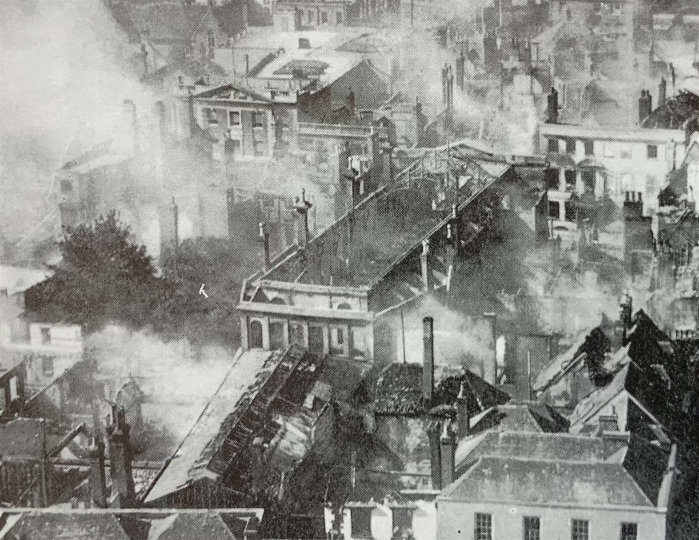
Yet some buildings did survive the Luftwaffe’s bombing including Marks & Spencer, which celebrates its 100th anniversary in the city this month.
*Pictures and information used with kind permission of Neil Mattingly, who has amassed a huge collection of historic postcards of Canterbury in years gone by. Information also taken from Canterbury Historical and Archaeological society's website.
Read more: All the latest news from Canterbury


