Unlimited Digital Access / Get £25 off your Annual Digital Subscription! Use code 25OFF
GET STARTEDMore on KentOnline
Unlimited Digital Access / Get £25 off your Annual Digital Subscription! Use code 25OFF
GET STARTEDMore on KentOnline
Home Sittingbourne News Article
A weather warning has been issued for thunderstorms this weekend – just a day after a heatwave was predicted.
The Met Office has confirmed that although many places in Kent will be largely dry, heavy rain and hail are likely to develop in some areas across the county.
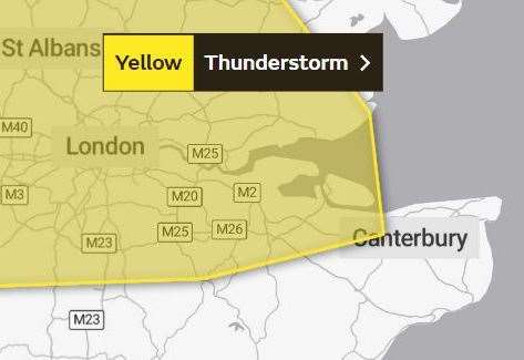
Despite temperatures being forecasted to reach 27C this weekend the warning is in place from 2pm until 9pm on Saturday.
A spokesman for the Met Office said: “There is a small chance that homes and businesses could be flooded quickly, with damage to some buildings from floodwater, lightning strikes, hail or strong winds.
“Spray and sudden flooding could lead to difficult driving conditions and some road closures.
“Where flooding or lightning strikes occur, there is a chance of delays and possibly even cancellations to rail services.
“There is a slight chance that power cuts could occur and other services to some homes and businesses could be temporarily lost.”
The warning comes just a day after the first heat health alert of the year was issued for Kent.
A yellow alert by the UK Health Security Agency and the Met Office is in place from 9am on tomorrow until 9am on Monday, as a heatwave is expected to sweep across the country.
Forecasters say temperatures will rise later this week and into the weekend, with a plume of warm air being drawn in from the south.
The mercury could peak at about 30C in some parts of England and remain well above average at night.