GO AD-FREE. Get 2 Months Digital Subscription for ONLY £1! Use code 2FOR1
GET STARTEDMore on KentOnline
GO AD-FREE. Get 2 Months Digital Subscription for ONLY £1! Use code 2FOR1
GET STARTEDMore on KentOnline
Flood alerts have been put in place across the county with heavy rain expected overnight.
A tidal surge is due to affect the north Kent coast this evening.

Among the areas with alerts is the Medway area.
The Environment Agency say areas at risk on the tidal Medway, Medway estuary and Isle of Grain include Aylesford, the Medway Towns, Lower Halstow, and Middle Stoke and Lower Stoke.
Flooding is possible in Dartford and Gravesham, as well as surround areas Northfleet and Greenhithe.
Heavy showers are also expected to affect the coast from Whitstable to Margate including Herne Bay, Reculver, Marshside, Saint Nicholas at Wade, Birchington and Westgate-on-Sea.
In addition, the Isle of Sheppey and coast from Kemsley to Seasalter has also received a flood warning.
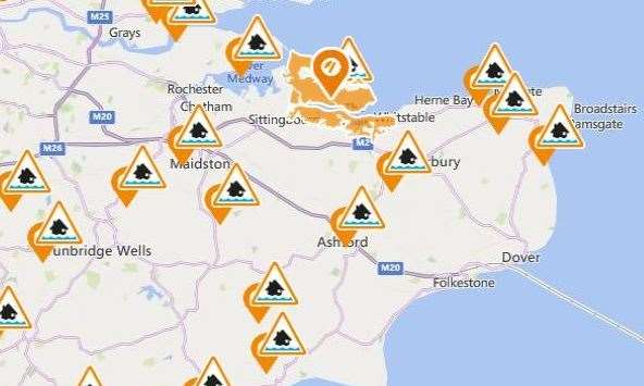
Sheerness, Minster, Queenborough, Leysdown, Sittingbourne and Faversham are also at risk.
The agency does not believe think properties are at risk, but has advised people to avoid walking along low-lying farmland or footpaths near the watercourses.
A spokesman said: "Please be careful along beaches, promenades, coastal footpaths and roads as large waves and sea spray could be dangerous.
"We are closely monitoring the situation."
The warning comes after the Ashford Designer Outlet overflow car park had to close today due to a flood risk.