GO AD-FREE. Get 2 Months Digital Subscription for ONLY £1! Use code 2FOR1
GET STARTEDMore on KentOnline
GO AD-FREE. Get 2 Months Digital Subscription for ONLY £1! Use code 2FOR1
GET STARTEDMore on KentOnline
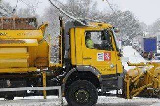
The gritters will be out in force across the county this evening as temperatures are expected to fall close or just below zero this evening.
It was revealed earlier this week Kent County Council's gritters were expected to take to the roads.
The authority set out its plans for tackling icy patches over the next few days, with conditions expected to get worse as the week continues and Kent Gritters tweeted earlier they would be out tonight.
The county is under an amber code, meaning road surface temperatures could drop to as low as zero and roads could also be damp.
Crews are also likely to be out on Thursday when the risk changes to red, meaning road temperatures are expected to fall below zero with a likelihood of ice, frost and snow.
The weather forecast throughout Kent remains cloudy throughout the week with highs of 9C. There is light rain and a moderate breeze.
Lows of -2C are expected overnight from Thursday into early Friday morning.
A Kent County Council spokesman said: “We will be treating all primary routes from 9.30pm due to road surface temperatures falling close to or just below zero overnight.
“Motorists are advised to watch out for icy patches, particularly on untreated roads overnight and into tomorrow morning and should expect the surface to be slippery.
“Drivers should be cautious and deliberate and slower in actions and not be surprised by sudden traffic light changes or other vehicles braking.
“Harsh braking, steering or harsh acceleration are key precursors to skidding on ice.
“Plan ahead, drive slower and brake in good time.”
Medway Council are also sending out their gritters as hoar frost and ice hazards are expected this evening in the Towns which means the gritters will be out treating the primary network tonight.
The Medway gritters should be finished completely by about 11.30pm.
The Met Office's UK outlook for the next 30 days is: "It will be mostly settled for a time on Friday, especially in the east, before thickening cloud and outbreaks of rain, perhaps with some hill snow, try to move eastwards later, with strong winds.
"The rain and hill snow will make further eastward progress on Saturday, perhaps with northeastern areas staying dry.
"Thereafter, it looks set to remain mainly cold, unsettled and sometimes windy, with gales possible in the north. Any milder spells will tend to be brief, and associated with longer spells of rain.
"The rain could turn to snow almost anywhere, but particularly across northern and central areas, especially later in this period."