GO AD FREE | Get your Digital Subscription for only 50p a week! Use code SUMMER
GET STARTEDMore on KentOnline
GO AD FREE | Get your Digital Subscription for only 50p a week! Use code SUMMER
GET STARTEDMore on KentOnline
According to headlines last year, by 2050 Kent’s coastline could look very different as a result of rising sea levels.
The Daily Mail reported areas could be underwater and “may have to be abandoned because of rising seas and coastal erosion”.
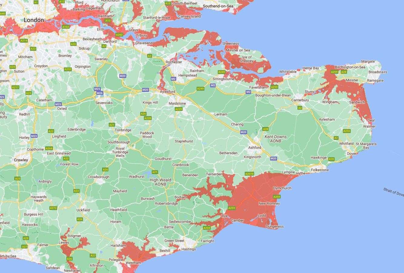
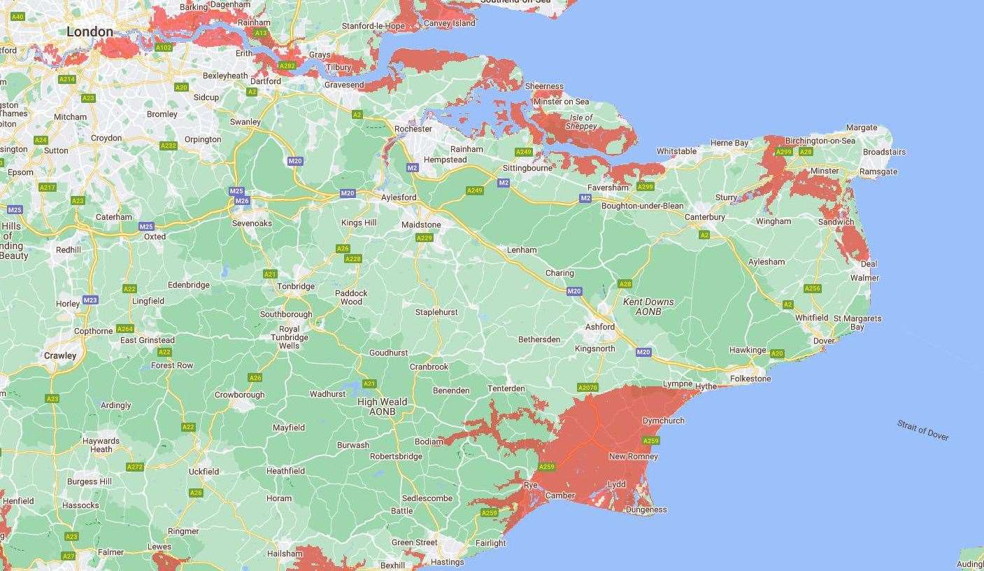
Much of the Romney Marsh, Sheppey, Isle of Grain and Hoo Peninsula would be swamped. Thanet would become an island once more, while Sittingbourne, Faversham, Deal and Sandwich could also see its coastline ingress inland.
Terrifying, certainly. Accurate? Not so much.
Which is not to diminish the scale of change we can expect as a direct consequence of climate change - but it’s important we don't fall victim to the false presentation of facts. Or, for that matter, that we all need to flee to the hills. At least, not quite yet.
The data on which the stories were published came from Climate Central, a highly respected, independent group of scientists. The policy-neutral, non-profit organisation crunches all the available climate change data, steps being taken to mitigate the risks and even factors in whether we get lucky or not (in other words will the predicted scenarios not play out). By doing so it plots maps of every area in the world and the likely impact of, for example, rising sea levels.
The reality isn’t quite as concerning for those living on the coast as it first appears. But don’t start relaxing just yet.
Peter Girard is vice president of communications for the US-based Climate Central. He explains: “Our maps can show either coastal flood risk, which communities would experience temporarily during storms, or projected future tidelines, which would expose them to regular inundation. In practical terms, a place at risk of flooding every day at high tide is essentially underwater.
“The Kent map shows land at risk during a coastal flood expected at least once a year by 2050, so not permanently underwater. ‘At risk’ means the height of the land is lower than the projected height of the water, but influences like wind speed and direction, or even distance from the sea, can affect risks during a coastal flood.
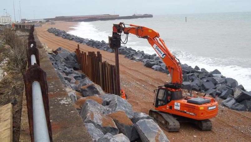
“In some cases and places, land at risk from coastal flooding as seas rise can be defended. Sea walls, levees, or more complex solutions like London's Thames Barrier are already protecting low-lying land from rising coastal flood risks.”
In other words, those maps depict flood risks – not the redefining of our coastline.
So we may not need to be building a bridge to reach Thanet from the mainland just yet.
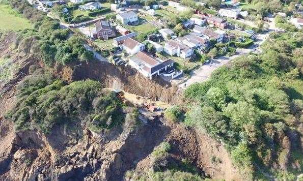
But Kent does face challenges not seen elsewhere in the nation.
Because while the sea levels are rising, the county is also, unfortunately, and perhaps surprisingly, sinking. Which means the impact will be exacerbated.
Plus, to make matters worse, even if every government around the world took all the steps necessary today to reduce greenhouse gases, the effect of what has already happened would still be felt for decades.
Dr Angela Hibbert is the head of sea level and ocean climate at the National Oceanography Centre – a research hub in Earth and ocean science.
She explains: “On the whole around the UK, sea levels are rising at around about the same level as it is globally. The IPCC [The Intergovernmental Panel on Climate Change – an intergovernmental body of the United Nations] said globally it is rising at around about 3.7mm a year. In the UK it's about 3.6mm overall.
“But what we see in Scotland is very different to what we see in the South East and that's because the South East is subsiding - so sea levels rise more.
“It's because of the last ice age. There was an ice sheet covering northern parts of Britain that squashed the crust down and the mantle, the soft bit underneath that, was squashed out and created a bulge at the front of the ice sheet - so across the South East of England.
“When the ice sheet melted, the northern part of the country started to rebound and the southern part started to sink and that's still continuing today.
“What we see from tidal observations is that rates of sea levels in the South East are increasing faster than in Scotland because of this combined effect.”
She estimates that the land on which we’re all standing on in Kent is dropping by around one millimetre a year. Not huge, but it adds up. Scotland, in contrast, is rising by around 1.5-2 mm a year.
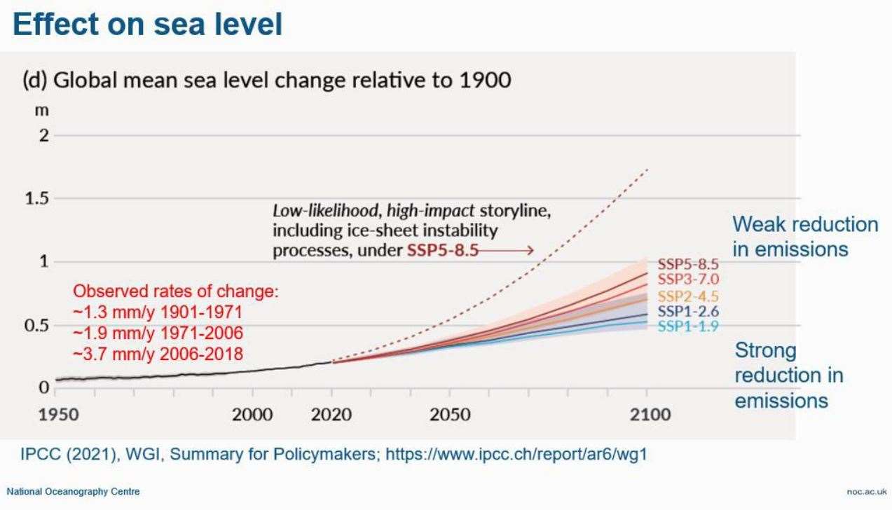
“It makes,” she adds, “sea level rise in the South East around 4.5mm a year.”
Those figures are determined by recording stations around the UK – which include Dover and Sheerness.
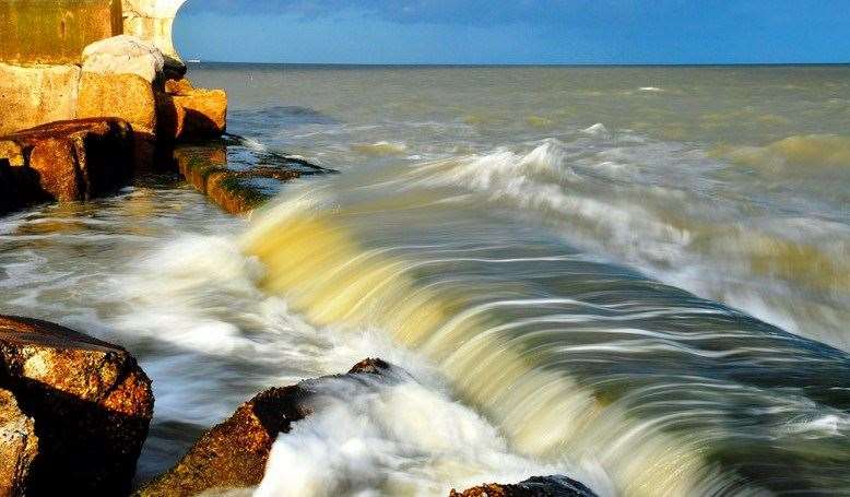
The consequence? Those living on or around the coast can expect more flooding.
Adds Climate Central’s Peter Girard: “Flooding during coastal storms will happen more often, extending further inland.
“Impacts will vary over seasons and years, but coastal flooding will generally worsen over time. In some low-lying areas, high tides around the new and full moons will cause minor coastal flooding even without the influence of storms, and these events, too, will happen more often and reach higher and further inland over time.
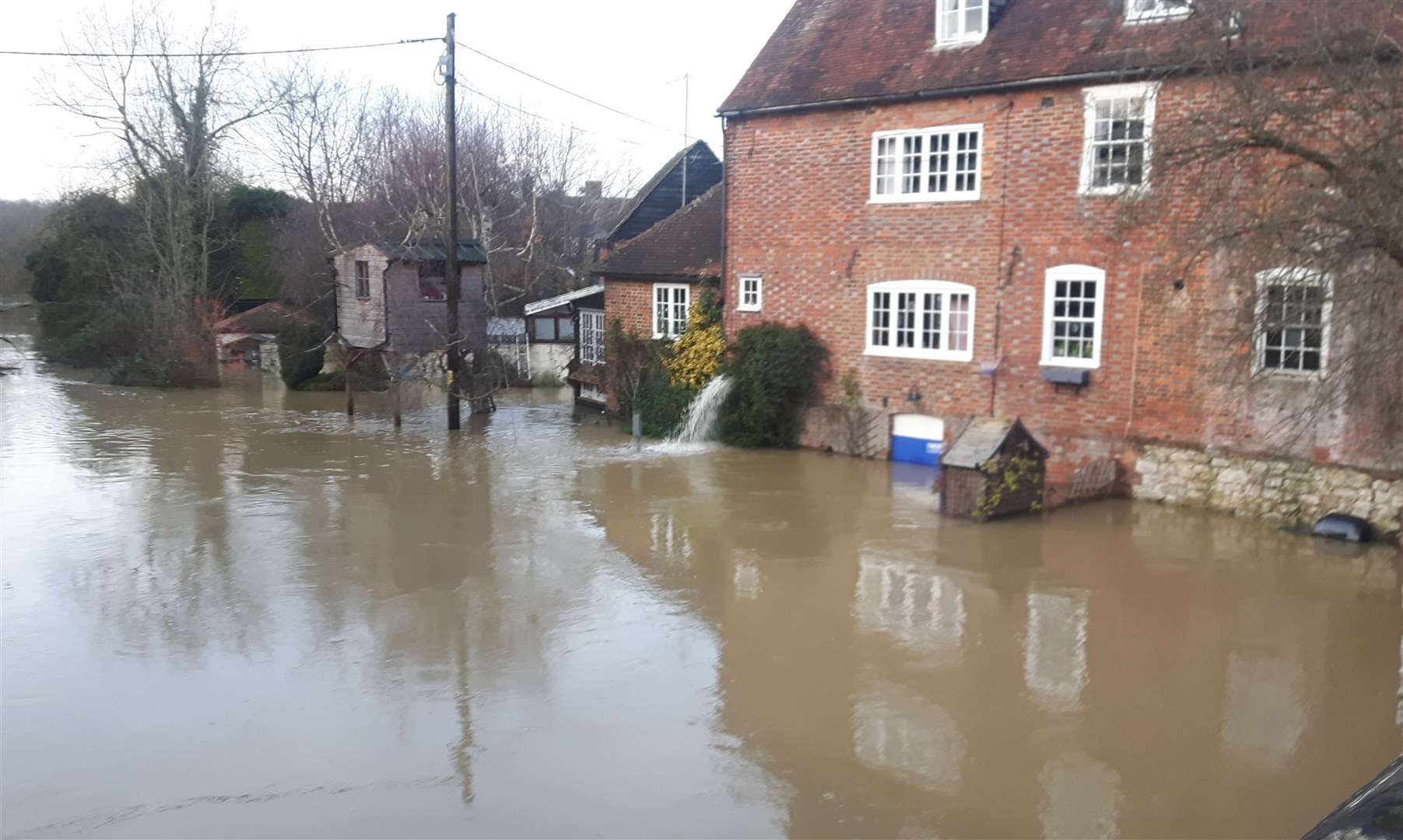
“And, as the rate of sea level rise continues to accelerate, changes that once seemed subtle will become more obvious, especially in the second half of this century.”
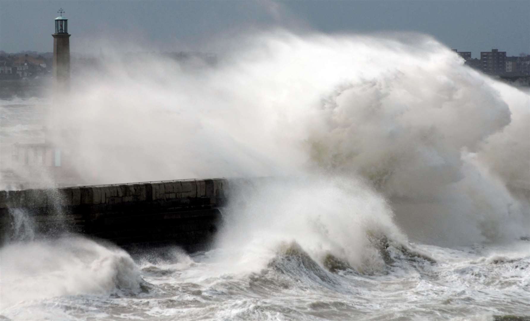
As an example, Dr Angela Hibbert of the National Oceanography Centre points to the North Sea storm surge which caused extensive flooding in 1953.
A combination of a high spring tide and windstorm toppled sea defences – most notably across the low-lying Netherlands and parts of Belgium. But it also caused major disruption along the east coast of the UK.
Sheerness, Seasalter, Whitstable, Herne Bay, Margate and Deal were among the worst-hit areas with even inland areas such as Maidstone failing to escape as water surged up the River Medway and burst its banks.
She explains: “At the time it occurred, it was thought to be a one-in-300-year event. We had another one of similar magnitude back in 2013. So only 60 years later, that one-in-300-year event has become a one-in-60-year event.”
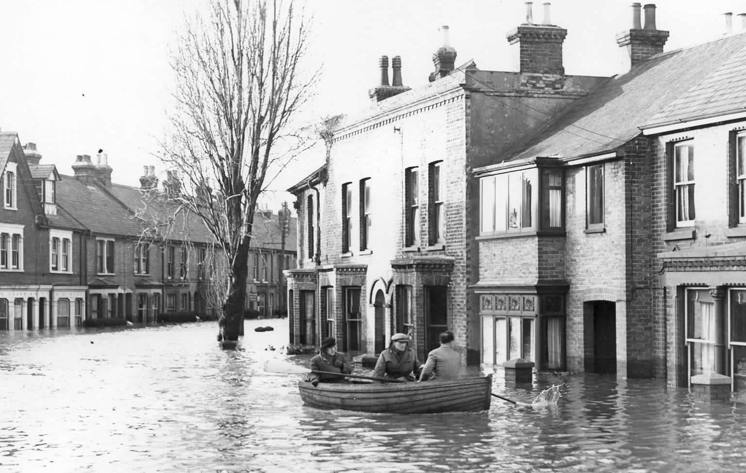
Fortunately for Kent, in 2013, the damage was minimal. But some £1 billion of damage was caused as flooding impacted Norfolk, Suffolk and Essex.
All of which brings into sharp focus the issue of housing around our coastlines – particularly those in the predicted flood-prone areas.
Adds Dr Hibbert: “Local authorities are looking at this - they're all very concerned.
“Planning authorities are looking at how high sea defences should be and whether they can justify housing developments in certain areas because of these potential issues.”
And that is a key aspect to all these projections. If mitigating steps are taken in terms of sea defences, then the impact of such flooding can be limited. But, as King Canute found out to his cost, we can’t turn back the tide.
“We are committed to a certain level of sea level rise now,” warns Dr Hibbert, “and that's because the oceans respond to warming climates over quite long time scales.
“Warming which occurred a significant time ago is still having an impact on the oceans. Sea levels will continue to rise for decades to come because of what we've already done. That's unavoidable now.
“The ocean has taken up that heat and it takes a while to work its way through.
“But, currently, indications are that for the UK the main impact, given the baseline sea level is increasing, is we won't necessarily have more storms or more intense storms, but we'll have the same number and because that baseline is increasing, those storms are what will produce increased coastal flooding.”
Sea levels are rising through a variety of factors – but most significantly the melting of the polar ice caps and warming waters due to elevated temperatures brought about by greenhouse gases. This triggers what is known as thermal expansion – when seawater molecules move slightly further apart, thus increasing the volume of water. Scientists from NASA suggest this accounts for 30% of all global sea level increases. Others suggest it is responsible for up to 50%.
We are committed to a certain level of sea level rise now...that’s unavoidable now
Yet many climate change deniers will point to the Earth going through cycles - of warming patterns reoccurring over centuries past - and how it is this, rather than mankind’s influence, which is causing the sea level rises we now see.
The scientists agree – to an extent – but point out the monitoring over the last 100 years is pointing the guilty finger in just one direction.
“Have sea levels risen in the past?” asks Dr Hibbert. “Absolutely, yes. We have had very dramatic swings in sea level - particularly after ice ages - in the past. They are driven by astronomical pressures, changes in the position of the Sun and things like that. But the evidence at the minute is that it is closely linked to greenhouse gas emissions and climate warming. That's the best indication of what is happening. It would be foolhardy to discount it.
“There's uncertainty in climate projection scenarios and there are certain parts of the science which is very poorly understood. Certain processes, such as the Antarctic ice sheets, are not well understood so there’s an awful lot of uncertainty as to what could happen there.
“There's a particular process around marine ice cliff instability and whether they could melt very slowly or if there's a sudden collapse. We just don't know.
“The potential for a sudden collapse is low, but if it does it could have a very high impact - so all of a sudden we could find it doubles the effect.”
And don’t just think the fact last summer was something of a damp squib compared to the scorcher of 2022 means things are moving in the right direction when it comes to cooling our oceans. These things take time.
“What people don't necessarily understand,” explains Dr Hibbert, “is that you don't necessarily see a year-on-year impact. Things don't get warmer every single year in a progressive way as there's such a lot of natural variability in the climate. You do get cycles of change which can occur over several decades so it can take quite a while for an acceleration to emerge.
“If you average sea levels globally, between 1901 and 1971 it was rising around 1.3mm a year. Between 1971 and 2006 it was 1.9mm a year and since 2006 it’s been at 3mm a year. We needed several decades of records to be able to be sure that was a true acceleration.
“You have to be really careful when you hear things like, 'Oh it's been the warmest year on record'. That doesn't mean the next year will be even warmer and the year after more, as you do get this natural variability. You have to be a bit circumspect and not scaremonger.”
Which brings us back to how Climate Central’s maps were incorrectly portrayed by many last year.
Let’s not be under any misapprehension - the impact of climate change does mean Kent will face more flooding, and more severe flooding at that, over the years. But the fact we know it’s coming may mean help is at hand - as long as we’re proactive.
Peter Girard from Climate Central concludes: “Invariably, the first thing people do when they see our maps is to look for their homes and that can be unsettling. But we've been encouraged by our work with planners around the world who use our maps to identify locations most at risk.
“Research has begun in many locations, projects have been designed and in some cases started, and people's lives and livelihoods and futures are more secure as a result.
“As for those who look on the maps we create with disbelief, for the most part, coastal residents do not need to be convinced that the climate is changing, that seas are rising, or that their homes are at risk, because they already see the dangers increasing.
“So our maps don't necessarily reveal hidden threats, but they do reduce some of the unknown dimensions of rising seas by identifying the lowest, most vulnerable areas along our coasts, and estimating when the risks are expected to climb.
“That knowledge can be used to understand what lies ahead and to begin planning for a future that looks different from the present. Seeing sea level rise and coastal flood projections in our maps can restore a measure of control in a world that feels increasingly uncertain.”
And, of course, while government inaction around the world remains alarming, we all have the power to play a part in easing the situation for generations to come.
“The lack of substantial action being taken is frustrating,” says Dr Angela Hibbert, “but for me, all I can do is follow the evidence and make changes myself. People have to take responsibility individually to do what they can. Those sorts of steps are likely to make significant inroads into what is happening. It will make it an awful lot easier.”


