GO AD FREE | Get your Digital Subscription for only 50p a week! Use code SUMMER
GET STARTEDMore on KentOnline
GO AD FREE | Get your Digital Subscription for only 50p a week! Use code SUMMER
GET STARTEDMore on KentOnline
Tankers and sandbags are on standby as the county is set to battered by "intense" thunderstorms and flash floods.
Four days of miserable weather is set to be inflicted on much of England, including Kent, which could cause travel chaos following a mini heatwave.
Earl Bourner is from KCC Highways
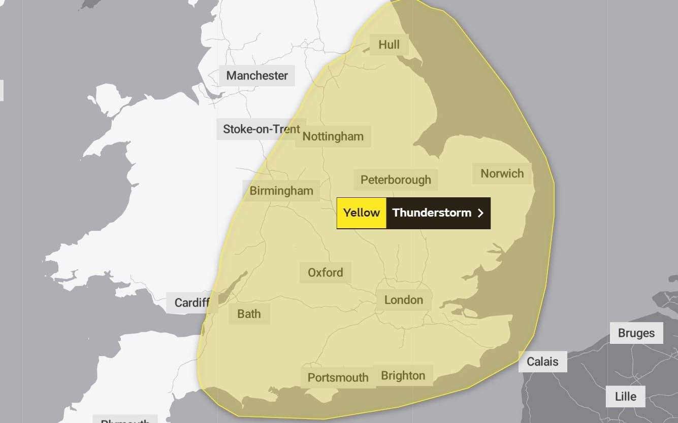
The first yellow weather warning issued by the Met Office is in force from 6pm on Wednesday until 11.59pm on Thursday night.
This will be followed by another warning, which is in place from 9am on Friday until 9am on Saturday.
Drainage and structures asset manager at Kent County Council (KCC) Earl Bourner has warned drainage systems may not be able to cope.
About 30mm of rainfall could come down in an hour, with some locations potentially receiving about 50mm in two to three hours.
"This level of rainfall in a short period of time really will impact drainage systems and these will surcharge which will lead to flooding problems on the network," he said.
"It’s been very dry so the ground isn’t going to soak the water as much so this could also deflect off and lead to further issues for us."
He has warned driving conditions could be "quite hazardous" and has urged people to drive slowly, leave enough braking distance and to report any hazards - such as fallen trees - to KCC.
Tankers, sandbags and 24 out of hours officers - which totals two per district - are on standby if areas are flooded.
Mr Bourner added: "At the moment it looks like quite a broad forecast so it could land anywhere in Kent and other surrounding areas.
"You can’t put all of the resources everywhere and we almost have to react after the incident.
"But it’s mindful for people who do know they’re in prone flood areas to maybe get ahead of the game. Look to see if the gullies in their road are clear, report them to us if they’re not and possibly think about some kind of flood protection for their own property."
The Met Office has warned there is a small chance homes and businesses could be flooded quickly, with damage to some buildings from floodwater, lightning strikes, hail and strong winds.
"Although there remains significant uncertainty in location and timing, areas of thunderstorms are expected to move northeast across parts of England and Wales from late Wednesday through to Friday morning," the weather forecaster said.
"Whilst not all locations will be affected, some intense thunderstorms may occur during this period with torrential rain, hail, frequent lightning and strong gusty winds possible.
"Rainfall totals of around 30 mm could fall in an hour, with some locations potentially receiving around 50 mm in 2-3 hours, although these will be fairly isolated."
The forecast continued: "Another spell of thundery rain is expected to push north across England and east Wales through Friday morning, persisting for much of the day, before clearing early on Saturday.
"There is some uncertainty in storm coverage, particularly western extent, but where they do develop torrential rain, intense thunderstorms, hail and frequent lightning are all possible.
"Rainfall totals of 20-40 mm, perhaps 60 mm in a few areas, are possible in 12 hours.
"With the most intense storms, 30-40 mm could fall in an hour or two. The storms should clear into the North Sea during Saturday morning."


